Samoa 34 Luthier in Fatu Hiva
We’ve received these beautiful photos of the Samoa 34 Luthier. They are sailing around the world and spending some time in Fatu Hiva. Click here
Based in Perth, Western Australia, B&G Yachts has been designing boats for almost forty years. Founded by Roberto Barros, designing boats for his own boatyard. Today B&G is managed by Luis Gouveia, having worked with Roberto Barros and Astrid Barros since 1992.
B&G Yachts also have experience with specialised designs such as Polar expeditions, shallow draft etc. If you don’t see the design you are looking for on our website, please get in touch and we can work on a custom plan for you. We also have partnerships with fabrication yards worldwide, so if you’re in need of recommendations we are here to help.
We’ve received these beautiful photos of the Samoa 34 Luthier. They are sailing around the world and spending some time in Fatu Hiva. Click here
Beautiful aerial footage of Corruira 46 navigating in Salvador. Contact us if you are interested in developing a custom design. Boat Plans – Corruira 42
If you love wooden construction, we recommend you watch these fantastic timelapse videos produced by Piotr Pawelec for the construction of his Brasileirinho in Poland.

SAILBOATS – CRUISING
Pop 20– 6.20 m (20.3 ft) costal sailing
Multichine 23 – 7.20 m (23.6 ft) costal sailing
Pop 25 – 7.54 m (24.7 ft) blue water cruising sailboat
Pantanal 25 – 7.65 m (25.1 ft) costal sailing, lifting keel, trailerable
Pop Alu 28 – 8.50 m (27.9 ft) blue water cruising sailboat
Multichine 26C – 8.74 m (28.7 ft) blue water cruising sailboat,
Samoa 28 – 8.80 m (28.9 ft) blue water cruising sailboat
Bora Bora 28 – 8.85 m (29.0 ft) coastal sailing catamaran
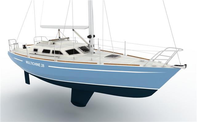
Multichine 28 – 9.20 m (30.2 ft) blue water cruising sailboat
Multichine 31 – 9.45 m (31.0 ft) blue water cruising sailboat
Pop Alu 32 – 9.88 m (32.4 ft) blue water cruising sailboat
Multichine 36 – 10.30 m (33.8 ft) /11.16m (38.1 ft) blue water cruising sailboat
Samoa 34 – 10.40 m (34.1 ft) blue water cruising sailboat
Cabo Horn 35 – 10.80 m (35.4 ft) blue water cruising sailboat
Kiribati 36 – 11.00 m (36.1 ft) blue water cruising sailboat, lifting keel
Samoa 36 – 11.00 m (36.1 ft) blue water cruising sailboat
Multichine 37 SK – 11.16 m (36.6 ft) blue water cruising sailboat, lifting keel
Multichine 38 Sport – 11.60 m (38.1 ft) performance cruising, blue water sailboat, lifting keel
Explorer 39 – 12.00 m (39.4 ft) blue water cruising sailboat, lifting keel
Aventura 40 – 12.27 m (40.3 ft) blue water cruising sailboat, classic style (contact us)
Cabo Horn 40 – 12.27 m (40.3 ft) blue water cruising sailboat
Multichine 41 – 12.48 m (40.9 ft) blue water cruising sailboat
Multichine 41SK – 12.48 m (40.9 ft) blue water cruising sailboat, lifting keel
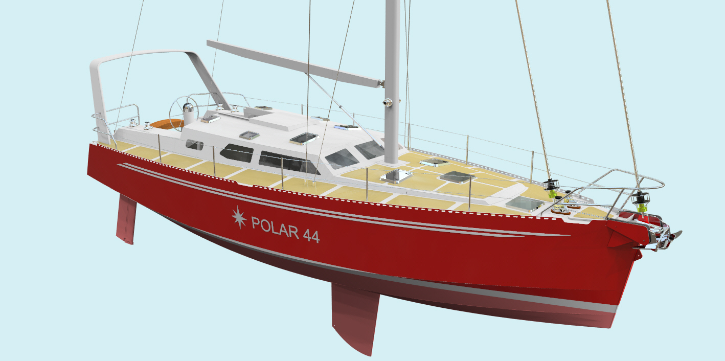
Polar 44 – 13.41 m (44.0 ft) blue water and high latitudes cruising sailboat
Polar 44 DS – 13.41 m (44.0 ft) blue water with, lifting keel, deck saloon
Multichine 45 – 13.70 m (44.9 ft) blue water cruising sailboat
Multichine 45SK – 13.70 m (44.9 ft) blue water cruising sailboat, lifting keel (contact us)
Polar 50 – 15.28 m (50.1 ft) blue water cruising sailboat, lifting keel (contact us)
Polar 65 – 20.00 m (65.6 ft) blue water and high latitudes cruising sailboat, lifting keel
Southern Cross 77 – 23.50 m (77.1 ft) blue water cruising sailboat
SAILBOATS – RACING
Micro 19 – 5.47 m (17.9 ft) performance sailing, lifting keel, trailerable
Green Flash 25 – 7.50 m (24.6 ft) sail racing (contact us)
Green Flash 33 – 9.90 m (32.5 ft) sail racing, ORC 33 class
POWERBOATS & TRAWLERS
Diamond 6.0 – 6.06 m (19.9 ft) sundecker powerboat, trailerable
Pilotina 25 – 7.60 m (24.9 ft) displacement trawler, costal
Southern Voyager 28 – 8.70 m (28.5 ft) displacement trawler, costal
Corruira 33 – 10.10 m (33.1 ft) displacement trawler, costal
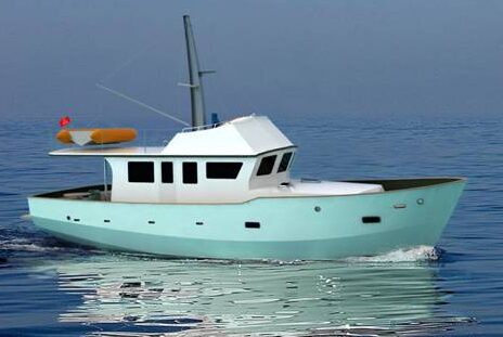
Corruira 42 – 12.88 m (42.3 ft) displacement trawler, costal and blue water
PODAY SAILING, ROWING & DINGHIES
Caravela 1.7 – 1.70 m (5.6 ft) sailing dinghy, tender, free project
Little Nomad – 2.30 m (7.5 ft) sailing dinghy, tender
Caravela 2.5 – 2.55 m (8.4 ft) sailing dinghy, tender (contact us)
Andorinha – 4.71 m (15.5 ft) daysailer, pleasure sailing and racing, trailerable
Brasileirinho – 6.00 m (19.7 ft) ocean rowing boat
Pop Star 21 – 6.40 m (21.0 ft) daysailer, pleasure sailing and racing, lifting keel, trailerable
SAILBOATS – CRUISING
Pop 20– 6.20 m (20.3 ft) costal sailing
Multichine 23 – 7.20 m (23.6 ft) costal sailing
Pop 25 – 7.54 m (24.7 ft) blue water cruising sailboat
Pantanal 25 – 7.65 m (25.1 ft) costal sailing, lifting keel, trailerable
Pop Alu 28 – 8.50 m (27.9 ft) blue water cruising sailboat
Multichine 26C – 8.74 m (28.7 ft) blue water cruising sailboat,
Samoa 28 – 8.80 m (28.9 ft) blue water cruising sailboat
Bora Bora 28 – 8.85 m (29.0 ft) coastal sailing catamaran
Multichine 28 – 9.20 m (30.2 ft) blue water cruising sailboat
Multichine 31 – 9.45 m (31.0 ft) blue water cruising sailboat
Pop Alu 32 – 9.88 m (32.4 ft) blue water cruising sailboat
Multichine 36 – 10.30 m (33.8 ft) /11.16m (38.1 ft) blue water cruising sailboat
Samoa 34 – 10.40 m (34.1 ft) blue water cruising sailboat
Cabo Horn 35 – 10.80 m (35.4 ft) blue water cruising sailboat
Kiribati 36 – 11.00 m (36.1 ft) blue water cruising sailboat, lifting keel
Samoa 36 – 11.00 m (36.1 ft) blue water cruising sailboat
Multichine 37 SK – 11.16 m (36.6 ft) blue water cruising sailboat, lifting keel
Multichine 38 Sport – 11.60 m (38.1 ft) performance cruising, blue water sailboat, lifting keel
Explorer 39 – 12.00 m (39.4 ft) blue water cruising sailboat, lifting keel
Aventura 40 – 12.27 m (40.3 ft) blue water cruising sailboat, classic style (contact us)
Cabo Horn 40 – 12.27 m (40.3 ft) blue water cruising sailboat
Multichine 41 – 12.48 m (40.9 ft) blue water cruising sailboat
Multichine 41SK – 12.48 m (40.9 ft) blue water cruising sailboat, lifting keel
Polar 44 – 13.41 m (44.0 ft) blue water and high latitudes cruising sailboat
Polar 44 DS – 13.41 m (44.0 ft) blue water with, lifting keel, deck saloon
Multichine 45 – 13.70 m (44.9 ft) blue water cruising sailboat
Multichine 45SK – 13.70 m (44.9 ft) blue water cruising sailboat, lifting keel (contact us)
Polar 50 – 15.28 m (50 ft) blue water cruising sailboat, lifting keel (contact us)
Polar 65 – 20.00 m (65.6 ft) blue water and high latitudes cruising sailboat, lifting keel
Southern Cross 77 – 23.50 m (77.1 ft) blue water cruising sailboat
SAILBOATS – RACING
Micro 19 – 5.47 m (17.9 ft) performance sailing, lifting keel, trailerable
Green Flash 25 – 7.50 m (24.6 ft) sail racing (contact us)
Green Flash 33 – 9.90 m (32.5 ft) sail racing, ORC 33 class
POWERBOATS & TRAWLERS
Diamond 6.0 – 6.06 m (19.9 ft) sundecker powerboat, trailerable
Pilotina 25 – 7.60 m (24.9 ft) displacement trawler, costal
Southern Voyager 28 – 8.70 m (28.5 ft) displacement trawler, costal
Corruira 33 – 10.10 m (33.1 ft) displacement trawler, costal
Corruira 42 – 12.88 m (42.3 ft) displacement trawler, costal and blue water
DAY SAILING, ROWING & DINGHIES
Caravela 1.7 – 1.70 m (5.6 ft) sailing dinghy, tender, free project
Little Nomad – 2.30 m (7.5 ft) sailing dinghy, tender
Caravela 2.5 – 2.55 m (8.4 ft) sailing dinghy, tender (contact us)
Andorinha – 4.71 m (15.5 ft) daysailer, pleasure sailing and racing, trailerable
Brasileirinho – 6.00 m (19.7 ft) ocean rowing boat
Pop Star 21 – 6.40 m (21.0 ft) daysailer, pleasure sailing and racing, lifting keel, trailerable